
Eye on the Storm
USF hurricane expert Jennifer Collins is tracking Tropical Storm Isaac. Here’s her latest assessment of the situation:
With the RNC coming to town, the nation is particularly focused on whether a hurricane will impact Florida. At this time, 20 years ago, we were also wondering if we would see a Florida landfall. In 1992, Hurricane Andrew strengthened into a Category 5 hurricane soon before crossing through the Bahamas. As it moved over the Bahamas, the system weakened slightly and then re- intensified into a Category 5 hurricane on August 24 before making landfall and devastating Homestead, Florida. Andrew happened in an inactive hurricane season, which goes to show that no matter whether the seasonal forecast storm count indicates that it will be an active or inactive hurricane season, it only takes one!
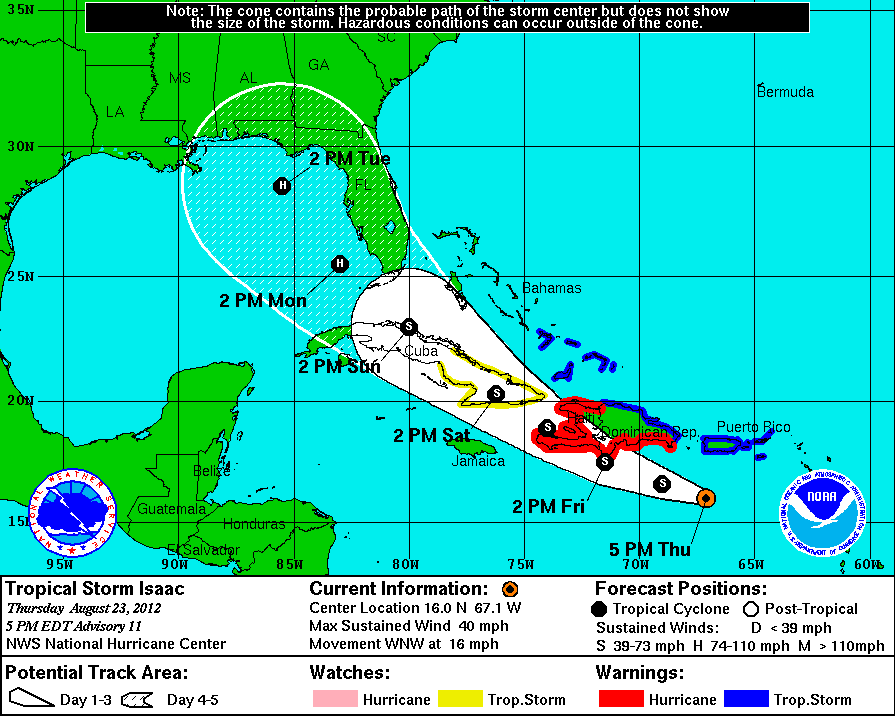
This season has been quite interesting to date. The season started early with two storms in May, prior to the official start of the hurricane season. Now we have tropical storms Isaac and Joyce we are tracking.
However, we are not out the woods for sure. Even with these models, we are still in the NHC forecast cone of uncertainty, and then one also has to consider the size of the storm even if the path is west of us. With Florida’s saturated soils currently, there is still a chance that we will have some significant impact from this system. Furthermore, it is worth noting that while most models are in agreement, there are still a couple that still take the system right up the FL peninsula. If it runs up the western coastline, we are also at an enhanced risk of tornadoes in the outer bands. Regarding the intensity of this storm in the next couple of days, I think this will be harder to predict partly due to land interaction and its effect on the system. Remember the 2005 season? There were many storms including Katrina, Rita and Wilma which intensified rapidly. Wilma dropped nearly 100 mb in a day to reach the record low pressure on record in the N. Atlantic. So let’s keep our ‘eye’ on this storm. Joyce – not much to worry about for Florida.
Visit the USF Weather Center for more information and listings for USF faculty hurricane experts.

Comments are closed.