
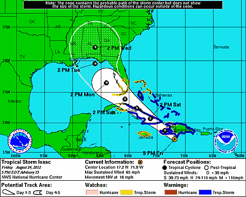
Isaac’s Track
USF hurricane expert Jennifer Collins continues her watch on Isaac as it continues its track toward the Gulf of Mexico. Here’s her latest assessment after today’s storm movement. Check out the USF Weather Center for more information.
Isaac continues to be a tropical storm, South Florida and the Florida keys have now received their first tropical storm watch. Depending on changes in
intensity of the system, this may be upgraded to a hurricane watch. Even without a direct hit, for us in Tampa, we are likely to experience at least tropical storm strength winds if it continues on its forecast track to possibly make landfall Tuesday afternoon in the panhandle.With that track, by Monday afternoon here in Tampa the outer bands of the storm are likely to be in the area. We could see heavy rainfall (contributing to flooding of the already saturated soils), gusty winds as well as potential tornadic activity associated with mini-supercells. Of course, I would like to emphasize again that one should focus on the entire cone for a possible landfall and Tampa is still included within that. A tropical storm watch is likely to be issued for the Tampa Bay area tomorrow. Some of the members of the GFS model ensembles still forecast the storm to travel up the peninsula, so direct landfall to South Florida or Tampa cannot be ruled out.
Tonight Haiti prepares for a tropical storm landfall, not the hurricane strength impact forecast a couple of days ago. This could still be particularly devastating for a country with some of its population living in tents after the recent earthquake.
Let’s all take a moment to remember that it was 20 years ago today, Hurricane Andrew made landfall at Homestead, FL. as a Category 5 hurricane with 165 mph maximum sustained winds. We owe our better preparedness to the lessons learned from that catastrophe and those who suffered in it.
National Hurricane Center map shows Isaac's tracks toward the Gulf of Mexico

Comments are closed.