
“Watch”ing the Tampa Bay Area
This evening’s assessment comes from USF PhD student David Roache who studies tropical weather with USF hurricane expert Jennifer Collins, who is making preparations in case she deploys a faculty and student team for a hurricane research project related to Isaac. Roache is co-author on two papers with Dr. Collins and award recipient of two Association of American Geographers Climate Specialty Group Student Paper Awards, 2010 and 2011, 1st place for the Graduate Student Paper of the Florida Society of Geographers’ Conference 2011 and the West Central Florida Chapter of the AMS Dewey Stowers Award, 2011.
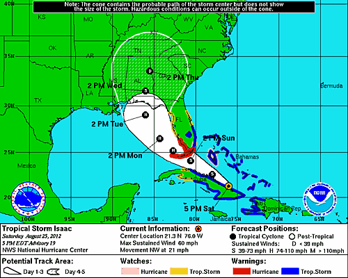
A tropical storm watch is now in effect for the Tampa Bay area, indicating that tropical storm conditions (with sustained winds of 39 to 73 mph) are possible within the next 48 hours. Currently located off the northern shore of eastern Cuba, Isaac remains a strong tropical storm with 60 mph maximum sustained winds. Moving to the northwest, Isaac is forecast to strengthen into a hurricane as it impacts the Florida Keys and enters the Gulf of Mexico.
While a direct landfall on Tampa is unlikely, as the area lies just outside the eastern edge of the cone, this does not mean that Isaac will pass by without impact. The outer bands of the cyclone may begin to reach the area as soon as Sunday evening, bringing with them gusty winds, heavy rainfall and the risk of isolated tornadoes. As such, all preparations for the storm should be completed by Sunday afternoon at the latest. As the center passes by to the west on Monday, tropical storm conditions will continue, and both inland and coastal flooding is possible – the former from the forecast 5-8” of rainfall and the latter from localized storm surges on the order of 4-7’.
The final landfall of Isaac is presently forecast to occur in the Florida panhandle, but could be as far west as New Orleans, LA. A more westerly track may result in a shorter duration of tropical storm conditions in our local region, but due to the large size of the storm Tampa will not go untouched by Isaac. It is also worth noting that environmental conditions in the Gulf of Mexico are conducive for Isaac to possibly undergo a period of rapid intensification, which would result in the cyclone becoming much stronger than currently forecast. See Dr. Collins’ previous post about rapid intensification. Such a scenario on Monday and Tuesday bears watching for all those with interests along the northern Gulf coast.

Comments are closed.